
Day 2. June 14, 2010. Launched from Sand Island at 0730 AM.
The interior of the Superdome in New Orleans has a volume of 125 million cubic feet. The amount of water flowing in the Columbia River during the four days of our great adventure was 500 thousand cubic feet per second, plus or minus. At this flow, called discharge by hydrologists, the Columbia River would fill the Superdome with water in 4.2 minutes.
Dry Bag and I selected the dates for our paddling trip to coincide with high flows in the river, as well as high tides. The lower Columbia River, from Bonneville Dam to the Pacific Ocean, a distance of about 145 miles, has two tidal cycles per day. Our plan was to be on the water every morning at high tide so we could ride the outgoing tide downstream. The river was very high in June of 2010.
To the casual observer on shore, a large river looks fairly placid, especially if the wind is calm and the water surface smooth. Sitting in a kayak, however, is a different perspective altogether. Paddling a river that is at flood stage, meaning that it is overtopping it's banks in places, combined with sets of very high and low tides, is akin to riding on the back of a wild beast. Add a strong wind blowing in your face, with associated waves up to three feet tall, and there are some thrilling moments!
 |
| Discharge and Stage at USGS gage, Beaver Depot, Oregon (RM 53.8). Stage is water surface elevation, and fluctuates twice daily with ocean tides. |
 |
| Sand Island downstream to Lord Island |
 |
| The blue diamond is my GPS point for our lunch spot on Lord Island. |
 |
| lunching on Lord Island |
Gull Island is at river mile 55, and we made our final landfall of the day there just before 5:00PM. We traveled 30 miles down river from our camp on Sand Island, and although it had been a long day of more than 9 hours on the river, we were back on schedule to make Astoria in 4 days.
 |
| Gull Island, unlabeled, is near the blue dot in the upper right corner of the image, next to Crims Island. |
We camped on Gull Island in a moss-covered meadow above the river. Dry Bag prepared a lovely meal, which we ate with much gusto. We were alone on the island, and the quiet was remarkable, other than the chirping chorus frogs in the nearby woods. I took a short walk on the beach, reveling in the solitude as day turned to dusk. There is very little river traffic this time of year; ocean-going vessels go by in both directions (paddlers need to know where the shipping lane is in the river), and there are a few fisher-persons on the river.
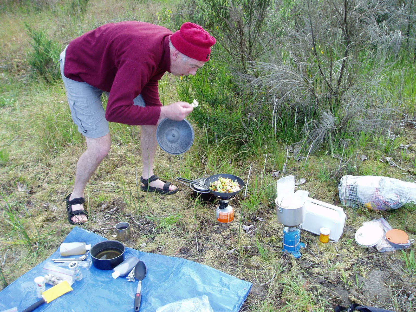 |
| Dry Bag preparing his famous camp meal. |
 |
| Mmmm...warm goodness, and great with a spork! |
 |
| Dry Bag Dave at Gull Island |
 |
| Paddlin' Paul at Gull Island |
 |
| Gull Island beach solitude |
 |
| Gull Island moss carpet |
Dry Bag crawled into his tent earlier than I did, and I walked away from camp to the edge of the woods and stood for awhile listening to the frogs. I crawled into my tent as the sky was darkening, and slept very deeply after our long day of paddling.
 |
| Woods and meadow on Gull Island |
Another derelict vessel. In the morning of Day 2 we passed an old derelict vessel that looked like a paddle-wheeler. This was near Goble, Oregon. Here's a video clip.
Coffin Rock (RM 73). In 1792 Lt. Broughton, sailing with the Captain George Vancouver Expedition, wrote in his log: several canoes covered the top of this islet, in which dead bodies were deposited." He was referring to what is now known as Coffin Rock. Some Northwest coast and Columbia River tribes placed their dead in canoes in special places, such as what we now call Coffin Rock and nearby Coffin Mountain. An account of this practice is here.
Lewis and Clark Bridge between Longview, Washington and Rainier, Oregon (RM 66). This bridge was designed by Joseph Strauss, who also designed the Golden Gate Bridge, and opened to traffic in 1930. At the time of it's opening, it was the longest cantilever bridge at 8,288 ft, and the highest, at 210 ft vertical clearance. When Bag and I paddled under the bridge, we went past one of the two bridge piers that was wrapped because of work being done (I assume it was being sand blasted and painted). At the end of the following video clip you can get a sense of the river velocity by looking at the large steel buoy we passed.
Mayger Fish Station, Oregon (RM 57.5). The fish station was built and opened in around 1910. It had a net shed where fishermen built, repaired and stored their nets, and a station where fish were purchased, packed in ice and shipped to canneries. The river was calm and there was a break in the weather when we stopped there to look and take photos, being careful not to get under this derelict structure. The net shed section, about 300 ft long, collapsed into the river in August, 2012.
---
No comments:
Post a Comment